Ijen Plateau


Ijen Plateau- Home-Grown Sulfur

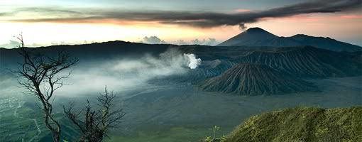
Ijen plateau or known as "Kawah Ijen" is highly recommended to mountain buffs and hikers. The Plateau was at one time a huge active crater, 134 sq km in area. Today, Ijen is a quiet but active volcano, and the landscape is dominated by the volcanic cones of Ijen (2,368 asl) and Merapi (2,800 asl) on the northeastern edge of the Plateau, and Raung (3,332 asl) on the southwest corner.
The magnificent turquoise sulfur lake of Kawah Ijen lies at 2148 m above sea level and is surrounded by the volcanos sheer crater walls. The vent is a source of sulfur and collectors work here, making the trek up to the crater and down to the lake every day. Sulfur collectors hike up in the morning and return around 1 pm when the clouds roll in. They carry shoulder basket of pure sulfur from a quarry on the lakes edge under the shadow of the sheer walls of the crater. The mineral at Kawah Ijen is purer and is worth commercial exploitation despite the horrendous labor involved: Javas homegrown sulfur is a natural source of sulfuric acid, in great demand in the oil-refining business and in the production of fertilizers.

Getting There

The Ijen Plateau can be reached through Bondowoso from either the northern or the southern coast. It is closer to Banyuwangi, but the road is very steep and badly deteriorated. A 4 WD is essential, although difficult to hire in Banyuwangi and outrageously expensive. Most people walk the last 8 km along the road to Pos Paltuding (the PHPA Post, the starting point or the trek to the crater).

Where to Stay

You can choose your places of stay at Bondowoso or Banyuwangi. There's a few type of accommodation with varied price and facilities.

Moving Around

You can take a walk for about 1-1 1/2 hour to the crater rim.

Dining Guide

Before start trekking, hiking or climbing, be sure that you have already eaten, or you can bring some food and drink from your places.of stay. Otherwise, you can buy some food and non alcoholic drink on the nearest supermarkets for your supply during your activities on mountain.

Souvenir Tips

The sulphur diggers will approach you for playing a guide and sell some nice sulphur statues for 5.000 till 10.000 Rp (probably their day-income).

Other Things to See or Do

At the rim itself you have a nice view on the lake. You can walk around the rim or go immediately left so you can walk down to the lake for about 40 minutes.

Travel Tips

*
The walk starts at Pal Tuding. Its a basic camp where you can stay overnight. There is a block with showers and toilets
*
At night it can be pretty cold up there,(it is suggested that you carry a sleeping bag). Take your own picnic, since the food you can buy at the parking lot isn't up to much.
*
The walk up to the crater rim takes 60-90 minutes. It's pretty steep. Halfway is a small post where the sulphurworkers take a break. A cup of tea is available here.
*
The path is just one-way so there is no need for any guidance.
*
An absolute must is a handkerchief to put in front of your mouth and nose to avoid inhalation of the sulphur gases.
*
If you buy some souvenirs like statues, they are very breakable so tape them in with toilet paper and take precious care of it.

Heritage


Jajaghu Temple

Jajaghu or Jago temple was constructed in 1275 - 1300 AD. It believed as the burial place of King Wisnuwardhana ashes, the fourth king of Singosari kingdom. The temple itself has three famous reliefs and each relief has their own story.

Kunjakarna relief which tells us about Kunjakarna who is doing Buddha meditation in Mt. Semeru in order to be free of his demon mind in the next incarnation. The second relief is about Arjuna journey to Indrakila mountain to train himself so he could be able to get Siva’s help and in this relief, it is told that Arjuna is succeed. Krisnayana relief is the third relief and it tells us about the marriage between Maharaja Wisnuwarddhana and his wife Nararya Waning Hyun in which symbolized the marriage between Visnu the God and Sri the Goddess.

There is also one remained statue in the yard of this temple, Amoghapasa the Highest God in Tantra Buddha whom has eight hands holding different things in each hands.

It is extremely interesting that the temple has ornament similarities to those of Penataran temple in Blitar Regency. It lies at Jago village, Tumpang District, the eastern part of Malang (about 22 km).


Sumber Awan Stupa

There are a lot of temples in Malang area, but Sumber Awan is the only building which is shaped in stupa. Lexically, Sumberawan comes from Sumber/spring and Awan/pond that means springs in the pond. This stupa was found in 1904 and renovated in 1937 by Dutch architecture Van Romondt.

The height of this temple is 2,23 cm and situated in Singosari District. To reach this area, we need to take a walk for 1,5 km and walk along a river banks with fresh clear water. The local settlements around the temple that are usually use the river to take a bath around the river side. Besides, you would also passing through fields’ area with its activities.

The spring water is believed as Amerta Water which usually drink by Gods and for people who drink it, it is believed that the drinker would be forever young and live longer.

The place around stupa was also called as paradise because its beautiful sceneries and natural surrounding. Nowadays, the temple area is still green and the surrounding is still far away from city touch.

Kidal Temple

The narrative poem Nagarakertagama identifies Candi Kidal as the burial shrine of King Anusapati of Singosari, who died in 1248. The temple may then be dated around the middle of the 13th century. A statue of Shiwa, said to have come from Kidal and thus assumed to be the portrait of Anusapati, is in the possession of the Royal Tropical Institute in Amsterdam.

This temple is located in Rejo Kidal village, Tumpang Sub District, 24 km away to the East from Malang. The Real height of the temple is 17 meters, but now it's just 12,4 meters. The temple base has a square shape. The door is one the West side. Above the door of the temple. there are " Kepala Kala " (Head of Giants) and lions. The temple was decorated using ornaments, which depict Mahabharata story not in sequence.

There is a well-known relief at the wall of this temple which is Garuda. The story is about Garuda’s journey in rescuing his mother from his stepmother’s slavery. The name of Kidal also related to the way the relief was pictured. It started from the left side, back side and finally the right side of the temple.

Malang Regency at a Glance


Malang, which is noted as one of the most fascinating town in east java lies in 90 km away to the south of the capital province, Surabaya. It considerably becomes one of clean and cool cities in east java. It is stretching out from 112′ 17′ 10,90″ to 112 57′ 0,00 East Longitude and ranging from 744′55, 11 to 8 26′ 35,45 South Latitude. Malang has border of Blitar and Kediri Regencies on the west; Jombang, Mojokerto and Pasuruan Regencies on the north; Probolinggo and Lumajang Regencies on the east and Indonesia Ocean on the south.

Without any doubt, Malang has distinctively been marvelous since a long time ago. Historical remnants scattered around Malang showing that it had played many important roles.

Malang is now officially divided into three administrative districts namely Malang Regency, Malang City and Batu City. Each of the three area has its own specialty of tourism attractions that you might stay in minimally 3 days to enjoy them.